The Ultimate Nusa Islands Helicopter Tour Route Guide
- It reveals the iconic, sheer limestone cliffs of Nusa Penida’s western shoreline.
- The route offers a unique macro-view of Nusa Lembongan’s intricate seaweed farms.
- It grants exclusive visual access to secluded coves and geological marvels like Broken Beach.
The low, rhythmic thrum of the rotor blades becomes the pulse of the morning. Below, the manicured greens of the Bukit Peninsula’s golf courses give way to the brilliant turquoise of the Badung Strait. You are ascending, the humid Balinese air whipping through the vents, and the familiar world of southern Bali is already shrinking into a mix of terracotta roofs and emerald rice paddies. This is the moment of transition, the departure from the known. In minutes, you will be over a different kind of Bali, a wilder, more elemental trio of islands where limestone cliffs plunge into sapphire water and the land itself feels raw and untamed. This is not just a tour; it is a geographical re-education, and the classroom is a state-of-the-art helicopter cabin. As a travel editor, I’ve seen Bali from every conceivable angle, but the perspective shift offered by this specific aerial route is profound. It’s the only way to truly comprehend the scale and majesty of the Nusa Islands.
Pre-Flight Briefing: Calibrating for an Elite Aerial Charter
Any seasoned traveler knows the experience begins long before takeoff. At the private Benoa Heliport, the atmosphere is one of calm professionalism. The standard aircraft for this route is often the Airbus H130, a machine known for its spacious cabin and exceptionally large windows—a critical feature for aerial photography. Its passenger capacity is deliberately limited to six, ensuring every seat is a window seat with an unobstructed field of view. Before you even approach the aircraft, your pilot—perhaps a seasoned veteran like Captain Wibowo, with over 5,000 flight hours over this very archipelago—conducts a meticulous briefing. This is more than a safety talk; it’s a strategic overview. He’ll point to a large-scale nautical chart, tracing the intended flight path, noting potential points of interest and discussing the day’s specific weather patterns. I always advise clients to use this time to express their interests. Are you an avid surfer hoping to spot the swells at Playgrounds? A geologist fascinated by karstic landscapes? Your pilot can often make micro-adjustments to the route, lingering for an extra 30 seconds over a feature that captures your imagination. This collaborative approach elevates the journey from a simple tour to a bespoke expedition, a hallmark of the premier Heli Fly Bali experience.
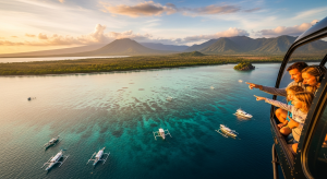
Leg One: Crossing the Strait to Nusa Lembongan’s Aquatic Patchwork
The flight across the 20-kilometer-wide Badung Strait is a journey between worlds. You leave behind the dense development of mainland Bali and head towards the comparatively rustic silhouette of Nusa Lembongan. The strait itself, plunging to depths of over 100 meters, is a vital marine corridor, and from an altitude of 1,500 feet, you can often spot the white wakes of fast boats ferrying passengers far below. As you approach Lembongan, the island’s primary economic driver becomes strikingly clear from the air. The shallow, protected bays on the island’s southern side are a mesmerizing patchwork of squares and rectangles in varying shades of green and brown. These are the seaweed farms, an industry that, for decades, has sustained the local population of approximately 5,000 people. From the ground, it’s difficult to grasp the scale of this aquacultural operation. From the air, it’s a living mosaic. The pilot will typically follow the coastline, giving you a clear view of Jungutbatu village, its beachfront bungalows appearing like tiny Monopoly pieces, before banking north towards the island’s dense mangrove forest, which covers nearly a quarter of its 8-square-kilometer area.
The Yellow Bridge and Ceningan’s Cerulean Depths
Connecting Nusa Lembongan to its smaller sibling, Nusa Ceningan, is the iconic “Yellow Bridge.” Officially named The Bridge of Love, this narrow, 138-meter-long suspension bridge is a vital lifeline for the local community. From your aerial vantage point, it appears as a delicate golden thread stitched between the two landmasses. The helicopter will often perform a slow orbit here, allowing you to appreciate the contrast between the bustling boat traffic in the channel and the quiet village life on either side. This is also your first glimpse of Nusa Ceningan, an island of only 3 square kilometers, defined by its rugged coastline and impossibly blue water. The star attraction here is the Blue Lagoon. While impressive from the cliffs, its true, almost supernatural, cerulean hue is only fully revealed from above. The pilot’s skill is on display as they navigate this tight space, showing you how the deep ocean currents have carved out this perfect cove. It’s a fleeting but powerful moment that underscores the unique value of the nusa islands helicopter tour route; you are seeing colors and shapes in the landscape that are physically impossible to perceive from sea level.
The Main Event: Unveiling Nusa Penida’s Jurassic West Coast
As you leave Ceningan behind, the pilot banks south, and the true scale of Nusa Penida comes into view. This is the largest of the three islands, a formidable limestone plateau covering over 200 square kilometers. The western coast is the tour’s dramatic centerpiece. The first landmark to appear is Kelingking Beach. Ground-based visitors must descend over 400 treacherous steps to reach its sands, but from the air, you see what they cannot: the complete, magnificent form of the T-Rex-shaped headland. The helicopter provides a 360-degree perspective, revealing the narrow spine of the “dinosaur” and the secluded beach cradled in its arm. The flight continues south along this unforgiving coastline, a wall of rock plunging 150 meters into the churning Indian Ocean. The next major feature is Pasih Uug, or Broken Beach. This is a geological marvel—a vast cavern whose roof has collapsed, creating a near-perfect circular cove with a natural archway allowing the tide to flow in and out. From the air, it looks like a giant’s eye staring up at the sky. Adjacent is Angel’s Billabong, a natural infinity pool carved into the rock. Seeing these formations sequentially from the air provides a profound understanding of the erosive power of the ocean, a story told over millennia that you can read in just a few minutes.
The Eastern Frontier and the Island’s Sacred Heart
While the west coast gets the most attention, a comprehensive nusa islands helicopter tour route includes a traverse across to the island’s eastern shores. This leg of the journey reveals a different side of Nusa Penida. You fly over the island’s surprisingly verdant and hilly interior, a landscape of small villages and subsistence farms that feels a world away from the tourist hubs of Bali. The eastern cliffs, while perhaps not as vertiginous as those in the west, possess their own severe beauty. The key sights here are Atuh Beach, a pristine white-sand crescent protected by a colossal rock arch, and the adjacent Diamond Beach. Nearby is the Thousand Islands (Raja Lima) viewpoint, where a series of dramatic sea stacks punctuate the turquoise water. From the air, you can spot the famous Rumah Pohon Molenteng, the treehouse perched precariously on a cliff edge. This part of the flight is also a poignant reminder of the island’s cultural significance. Nusa Penida is deeply respected within Balinese Hinduism and is an important part of the region’s spiritual ecosystem, a concept aligned with the Tri Hita Karana philosophy which is recognized by UNESCO as a Masterpiece of the Oral and Intangible Heritage of Humanity. This isn’t just a scenic flight; it’s a glimpse into the island’s soul.
Quick FAQ: Your Nusa Islands Helicopter Tour Route Questions Answered
What is the total flight time for a typical Nusa Islands tour? The standard aerial circuit lasts between 45 and 60 minutes, from takeoff at Benoa Heliport to landing. This duration is optimized to cover all key landmarks on the three islands without feeling rushed, allowing ample time for observation and photography over each major site.
What is the best time of day to fly for optimal visibility and photography? I consistently recommend a mid-morning departure, between 9 AM and 11 AM. During this window, the sun is high enough to illuminate the cliffs and bring out the vibrant colors of the water, while the coastal haze that can build up in the afternoon is typically at a minimum. The pre-sunset “golden hour” offers spectacular light but carries a slightly higher risk of cloud cover.
Can the pilot customize the flight path? While all flights operate under strict air traffic control regulations, there is often flexibility. Minor deviations, such as performing an extra orbit over Kelingking Beach or spending more time observing manta rays off the coast, are frequently possible. It is best to discuss your specific interests with your Heli Fly Bali coordinator and pilot during the pre-flight briefing to tailor the experience.
What is the passenger capacity of the helicopters used for this route? The preferred aircraft for this tour, such as the Airbus H130 or Bell 505, typically seats 4 to 6 passengers. This small group size ensures an intimate and comfortable journey, where every passenger has direct access to a window and clear communication with the pilot.
To witness the Nusa Islands from above is to fundamentally change your understanding of Bali’s geography. It is an experience that trades crowded ferries and treacherous roads for an elegant, panoramic perspective that reveals the raw, sculptural power of nature. This is not merely about convenience; it is about comprehension, about seeing the intricate connections between these three islands and the powerful ocean that shapes them. To map out your own aerial journey and gain this exclusive perspective, explore the bespoke charters offered by the experts at Heli Fly Bali. The islands, in all their untamed glory, are waiting.